An Antarctic-bound drilling rig has had modifications tested near Martinborough before it’s shipped to the ice as a key part of an international climate change project which is checking the stability of the West Antarctic Ice Shelf.
A full melt of the ice field has been recorded once before in rock sediments below the sea floor in the last interglacial period, 125,000 years ago. The plan: drill into the sea floor, retrieve the core and analyse its climate record for the last time Earth’s temperatures were 1.0 – 1.5deg Celsius above pre-industrial levels.
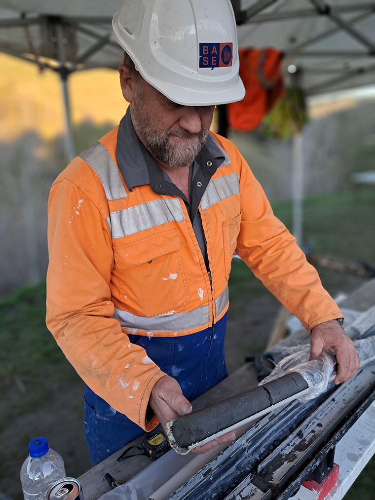
Victoria University geologist Cliff Atkins told The Star the team were “testing this rig out. It was designed to do drilling in Antarctica, has been down there a couple of times … as part of a multi-national science project and we’ve made some modifications.” Victoria University’s geologists have run geology field trips “to Mangapari Station for 45 years or so … so I talked to the farmer and asked if we could drill a hole in your paddock just to test this (modified) rig out and check that it’s behaving properly and get a core of the mudstone that’s all through here.”
“There’s an amazing geological story running through these hills and we wanted to core through a mudstone unit not too dissimilar to the kind of thing we’re going to drill in Antarctica.”
The test checked the modified drill’s behaviour and also retrieved 120 meters of mudstone core from the drill site. “We’re getting a core up that’s about 5 centimeters wide … and there’ll be a neat story in the layers which I’m going to use with students –
and we might do a bit of science on that core as well,” Dr Atkins said. But first they will pack the drill off to the ice.
“We’ll go to Antarctica with a drill crew (locate the rig about 900 kilometers from Scott Base) and drill into the ice several hundred meters down.”
A joint Victoria University/GNS Science project, it includes scientists from another 10 partner countries and “millions of dollars” in funding. The drill programme is known as SWAIS2C (“Sensitivity of the West Antarctic Ice Sheet to 2degCelsius of warming.”)
“We are trying find out how sensitive the ice shelf and the ice sheet are, as we know the ice sheet and ice shelf have disappeared in the past,” Atkins said.
“We want to know when did that point happen so we need the rock (samples) to know how close we are to the point when we lose the ice shelf. Once that rock ice shelf has gone there’s nothing holding back the ice sheet and then things start to move and slide.
“So it’s a critical point and we really need to understand what happened the last time this happened in the past and how close we are to that threshold. That’s the big drive behind the project.

New Zealand is in charge of the drilling programme but people from many countries will come together as the team on the ice. “So it’s 2degC warmer than pre-industrial and we’re already at 1.5degC. We’re getting very close to that point where the Ross Ice Shelf simply can’t exist and … that huge area the size of France is gone and it’s open ocean. When that
happens the (land-based) ice sheets flow into it (the sea) much quicker. We need to know how close we are to that point.”
GNS Science geologist Paddy Power said the drilling work had helped the team test the upgraded drill and associated tools and drill bits. The core of mudstone will be studied in the lab “over the next few months.”
An advance party from the Antarctic programme goes to the ice in October to prepare to tow the drill some 900 km to the site, with the rest due to fly down in November.
“We will be on site through till about Christmas then we should all fly home by the end of January,” with about 200 meters of rock core that will “help tell us what was happening in the world the last time the ice shelf collapsed.”
That shelf is seen “as a plug and if that disappears the glacier ice behind it will speed up and a lot more glacier ice will be going into the ocean,” Dr Power said.
The Martinborough mudstone “core” story will include water depths and sea temperatures in the distant past when the mudstone was deposited, Dr Atkins said. “The mudstone near the bottom will be about 8 or 9 million years old – and at the bottom the mudstone is about 10 million years old, so this is the older part of the area.
“Before it was uplifted by the (Pacific) plate boundary and the faults this was all in a marine basin and the mudstone we’re drilling into was probably deposited in 400 to 500 meters of water depth – before this landscape existed and Wairarapa was under the ocean. “This (whole area) has been pretty rapidly uplifted in the past couple of million years as the ranges … have come up and a big long sea-way existed through the Wairarapa called the Ruataniwha Strait … until … it finally got uplifted and squeezed and dried out and became the Wairarapa Basin.”
“You can trace the limestones all the way up the margins of the Wairarapa through Hawke’s Bay that were deposited in the seaway that existed. (Tectonic plate pressure means) they have all been tilted up into a bunch of anticlines and synclines. “So there are a whole lot of faults and folds as the whole Wairarapa and east coast of the North Island has been squished by the Pacific plate.
“The whole lot has been … rumpled up like a carpet – and this (hill area) is one of the rumples. You go over another one as you go into Martinborough – through the Harris Rise – and you go over another one on the flats heading towards Featherston – another rumple in the geological carpet,” Atkins explained.
The drilling area was part of a deep marine basin off the coast of what was to become New Zealand as we know it. It was open to the ocean in quite deep water with some land around shedding sediment into that deep marine basin and then it was slowly lifted up and became shallower and with shallower and younger sediment on top.
“Then the lot has come out of the sea, became emergent, about 1.6 million years ago and then we get layers of river gravels deposited on top of the marine rocks – and that’s the story my students map out here … it’s a great training ground for them.”
There is a climate story in the core which the drill retrieved. “To look at it, it’s fairly monotonous gray mudstone and you can’t see much in the way of alternating layers, but there are changes … and fossils in there. When we analyse the fossils we can see time in that core, and we can see changes in water depth and changes in water temperature and we can relate that to climate cycles and what the weather was doing at the time,” he added. In the younger rock there “is quite a clear signal and the glacial and inter-glacial (climate) cycles” arte recorded.
He notes the limestone deposits are full of the fossils of cold water scallops in the mudstone – “and (it’s) a species of scallops that still exists – you can buy them in the supermarkets.” The scallop species has a cold water affinity so the limestones formed through the whole basin indicate when the sea was cold, when sea volumes were lower and ice volumes in the Antarctic and Arctic were bigger. “Then we go into warm climate, the water deepens, we lose the limestone – then the limestone comes back again,” hee said. “So we have a very clear signature in the sedimentary layers of the climate … cycles of the past.”
The site near Martinborough has been in use for geological research for more than 50 years, Atkins noted. Students who study the geology of the area have a week to map the key features and using the structure they reveal “they work out the climate story and the environmental story that’s told by all those layers which have been deposited over time.” Among the finds are what he called “green sands” in which occasionally “huge big sharks’ teeth” – 7–8 centimeters long – from the giant sharks which once swam in the seas are found, along with quartzite boulders “rafted from Antarctica in icebergs and dropped in the (local) seas,” as well as “volcanic ash layers we find a few new ones now and again. There’s always something new to be found,” he added. SWAIS2C info www.swais2c.aq